Iceland Road Atlas 1:200.000, Spiralbound (English, French and German Edition)
Book details
Summary
Description
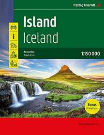
The Travel Atlas Iceland 1:150,000 is the ideal companion for anyone who wants to explore Iceland by car or public transport. It can not only be used for planning, but also proves to be an indispensable guide during the trip. With the detailed map image and the exact scale, the entire road network on the island, including the highland roads, can be traced. The Ring Road (Hringvegur) is highlighted with its own road signature and both the Golden Circle (Gullni hringurinn) and the Arctic Coast Way (Norðurstrandarleið) are marked as tourist roads. Drivers can extract particularly useful information from the maps, such as road surface, fords (river crossings), rest areas, petrol stations and garages. Caravan drivers and campers will find a useful directory of campsites and pitches. For those travelers who prefer to travel by bus, a general public transport map is available. Information on the travel atlas of Iceland Iceland 1:150,000 18 city and town plans 232 pages, format 21 x 29.7 cm (A4) Semi-concealed spiral binding Campsites and pitches, accommodation 30 highlights described Directory of places and bodies of water To help Iceland visitors find their way around the island, tourism-related information, including national parks and wildlife sanctuaries, scenic views, waterfalls, hot springs and popular whale-watching spots, has been visualized on the maps. Like no other European country, the island state of Iceland (Ísland) is characterized by dormant volcanoes, bare lava fields, mighty glaciers, spouting geysers, thundering waterfalls, natural rivers and hot and cold springs. It's the land of extremes, where water slugs gently from the ground, fountains erupt wildly from underground and the earth trembles at regular intervals, but where fertile river valleys and gentle coastal stretches also extend.


We would LOVE it if you could help us and other readers by reviewing the book

