Military History Map Pack - Battles of the Revolutionary & Civil Wars
Book details
Summary
Description
Two great maps by National Geographic show the geography of two of America's most important wars, packaged together at a special price (MSRP $15.90 if purchased separately).
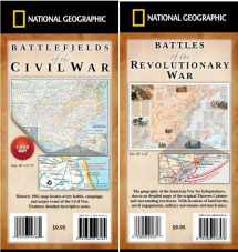
Battlefields of the Civil War map, first published in 1961, locates every battle, campaign and major event of the war. Features detailed descriptive notes. Side one of the map covers the main region of the War from New Jersey to Louisiana. The map portrays the country as it was charted in 1863. It is based on a map on which General Grant marked his proposed lines of operation. An inset charts the major offensive of each army. Side two features more detailed maps, including "Cockpit of the Civil War" covering the area from southern Pennsylvania to southern Virginia, an inset of Gettysburg, an inset titled "Grant at Richmond", a map of War in the Southwest from Texas to California, an inset of the Vicksburg Campaign, maps of Nashville to Atlanta and Memphis to Huntsville, and an inset of battles for Atlanta. Every battle is located with a crossed-swords symbol. All key battles and events are described with National Geographic's renowned map notes. Printed two sides, 28" x 22", folded to 4" x 9".
Battles of the Revolutionary War map depicts the geography of the American War for Independence, shown on detailed maps of the original Thirteen Colonies and surrounding territories. With locations of land battles, naval engagements, military movements and more. Features inset maps of New York & New Jersey, The War at Sea, Yorktown; many sidebars, including Saratoga Campaign, Invasion of Canada, The Carolinas Campaign, Black Americans; detailed descriptive notes; colorful illustrations. Printed on quality paper. Size: 36" x 24", folded to 4" x 9".


We would LOVE it if you could help us and other readers by reviewing the book

