Then and Now Bible Maps - Fold out Pamphlet
Book details
Summary
Description
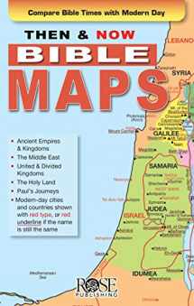
Where are the Bible lands today? Where were Iraq and Iran in Bible times? The answers to these questions and countless others are found in the bestselling pamphlet Then & Now Bible Maps. This full-color, fold-out reference tool contains 17 Bible maps that show ancient cities and countries in black with modern-day boundaries marked in red. Fantastic for comparing places in the news with places in the Bible. Size: 8.5"x 5.5" unfolds to 38" long. Fits inside most Bible covers. Teachers love the amazing Then & Now Bible Maps reference tool. Seventeen maps make the Bible more relevant and more meaningful by providing visual context. Show students where Persia is today and the places Paul’s first missionary journey would take him if traveling the same route today. Help them understand the biblical geographic context of the places they hear in the news every day. Here are a few of the maps included in this incredible resource:
- The Middle East map during Bible Times and Today
- The Assyrian Empire, Babylonian Kingdoms and Persian Empire
- The Holy Land Map Then and Now
- Places of Jesus’ Ministry Then and Now
- The Holy Land: Then (1300 BC—Twelve Tribes) and Now (modern times) uses color coding to show Canaan divided by the Twelve Tribes, and also shows the historical and modern-day names of cities within the regions occupied by the Twelve Tribes
- Paul’s Journeys: Then (AD 47-62) and Now (modern times) show one of the Seven Churches of Asia (Rev. 1-3), cities, towns, ancient ruins, mountains, modern capital cities and a key for measuring the distance traveled from city to city
- Empires & Kingdoms: Then and Now shows the changing boundaries of the Assyrian Empire, Babylonian Kingdom, and Persian Empire


We would LOVE it if you could help us and other readers by reviewing the book

