Extra-large USA Laminated Wall Map - 45'' high x 67'' wide
Book details
Summary
Description
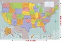
Extra-large laminated map of the United States measures more than 5.5 feet wide and 3.75 feet high!
Ideal for school, office, or home. Use a dry erase marker to write on the map's laminated surface and easily wipe off. (Dry erase marker not included.) All 50 States are featured, with insets for Alaska and the Hawaiian Islands. Map also includes insets for Guam, American Samoa, Puerto Rico, U.S. Virgin Islands, and Northern Marianas. States and territories are clearly differentiated with bright colors. Map identifies capital cities, major cities, and places of interest. Essential geographical features, such as mountains and rivers, are also included. Extra-large map is durable and reusable. Map is creaseless -- it comes rolled in a plastic tube. Sturdy 157 gsm paper stock is laminated on both sides at 3 mil thickness. 2-sided lamination makes map moisture-resistant. Map is suitable for framing with or without glass, and suitable for hanging unframed. Map measures an extra-large 67'' wide x 45'' high -- that's more than 5.5 feet wide and 3.75 feet high! Mercator projection is used for optimal display. Map by master cartographer by David Lindroth. Map comes in a clear plastic tube that may be used for storage.


We would LOVE it if you could help us and other readers by reviewing the book

