Arizona Road & Recreation Atlas (Benchmark Recreation Atlases)
Book details
Summary
Description
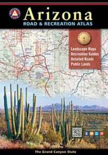
All New Landscape MapsTM National Forest land ownership (private in-holdings) are shown in addition to forest boundaries Updated road conditions compiled from annual Motor-Vehicle Use (MVU) data by US Forest Service BLM/State land ownership Page to page map overlap, clear legibility Recreation Guide Public Lands maps are completely updated with recreation access and point-to-point mileages Recreation listings are current and fact-checked Categorized listings include: Parks, Monuments, Natural Wonders Campgrounds & RV Parks Boating & Fishing Access Forest & Wildlife Areas Hunting Unit Map with Info Resources The Grand Canyon State abounds in natural beauty and outdoor possibilities. With completely reworked Landscape Maps and a comprehensive Recreation Guide, Benchmark's Arizona Road and Recreation Atlas is an invaluable resource for adventure planning and exploration. The regional Recreation Guides show public land access and categorized points of interest with descriptions and details found in no other map product. Landscape Maps provide the largest scale and 54 pages of highly detailed road classifications and conditions. The base layers show land cover (vegetation) and land ownership including private in-holdings within national forest boundaries.


We would LOVE it if you could help us and other readers by reviewing the book

