Rand Mcnally Portland Regional Map (Green Cover) (Rand Mcnally Regional Map)
ISBN-13:
9780528008702
ISBN-10:
0528008706
Edition:
Fold Map
Author:
Rand McNally
Publication date:
2014
Publisher:
Rand McNally
Format:
Map
2 pages
Category:
Atlases & Maps
FREE US shipping
Book details
ISBN-13:
9780528008702
ISBN-10:
0528008706
Edition:
Fold Map
Author:
Rand McNally
Publication date:
2014
Publisher:
Rand McNally
Format:
Map
2 pages
Category:
Atlases & Maps
Summary
Rand Mcnally Portland Regional Map (Green Cover) (Rand Mcnally Regional Map) (ISBN-13: 9780528008702 and ISBN-10: 0528008706), written by authors
Rand McNally, was published by Rand McNally in 2014.
With an overall rating of 3.8 stars, it's a notable title among other
Atlases & Maps
books. You can easily purchase or rent Rand Mcnally Portland Regional Map (Green Cover) (Rand Mcnally Regional Map) (Map) from BooksRun,
along with many other new and used
Atlases & Maps
books
and textbooks.
And, if you're looking to sell your copy, our current buyback offer is $0.3.
Description
NOTE: The map is intentionally made with description boxes that cover parts of the map.
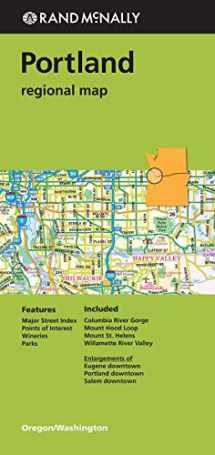
Rand McNally's folded map for Portland is a must-have for anyone traveling in and around this part of Oregon, offering unbeatable accuracy and reliability at a great price. Our trusted cartography shows all Interstate, U.S., state, and county highways, along with clearly indicated parks, points of interest, airports, county boundaries, and streets. The easy-to-use legend and detailed index make for quick and easy location of destinations. You'll see why Rand McNally folded maps have been the trusted standard for years.
Product Description
.
Regularly updated
Full-color maps
Clearly labeled Interstate, U.S., state, and county highways
Indications of parks, points of interest, airports, county boundaries, downtown & vicinity maps
Major attractions & Golf Courses
Enlargements of Eugene downtown, Portland downtown, Salem downtown
Easy-to-use legend
Detailed index & Major Street Index
Convenient folded size
2014
Coverage Area Columbia River Gorge, Mount Hood Loop, Mount St. Helens, Willamette River Valley


We would LOVE it if you could help us and other readers by reviewing the book

{user}
{createdAt}
{truncated_title}
{author_block}
by {truncated_author}
