National Geographic Africa Wall Map - Classic (24 x 30.75 in) (National Geographic Reference Map)
Book details
Summary
Description
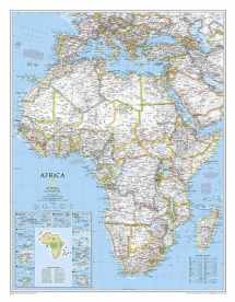
National Geographic's map of Africa is as attractive as it is functional. The entire continent is rendered in the Classic style with colorful, clearly defined international borders, shaded relief, and easy-to-read fonts. Place names, bodies of water, airports, major highways and roads, as well as cartographic patterns used to depict sand, lava fields, swamps, dry salt lakes, intermittent lakes, salt deserts, and areas below sea level are shown as well. This map also includes an informative inset on climate and terrain with a topographic map of the continent and individual insets of the 10 island nations surrounding Africa.
Coverage includes the following countries, their capitals, and major cities: Algeria, Angola, Benin, Botswana, Burkina Faso, Burundi, Cameroon, Cape Verde, Central African Republic, Chad, Democratic Republic of the Congo, Republic of Congo, C?te d'Ivoire, Djibouti, Egypt, Equatorial Guinea, Eritrea, Ethiopia, Gabon, Gambia, Ghana, Guinea, Guinea-Bissau, Kenya, Liberia, Libya, Madagascar, Malawi, Mali, Mauritania, Morocco, Mozambique, Namibia, Niger, Nigeria, Rwanda, Senegal, Sierra Leone, Somalia, South Africa, Sudan, South Sudan, Tanzania, Togo, Tunisia, Uganda, Zambia, and Zimbabwe. The island nations shown are: Canary Islands, Madeira Islands, Comoros, Seychelles, Mauritius, Rodrigues, Reunion, Sao Tome and Principe, Bioko, and Cape Verde.
The map is packaged in a two inch diamater clear plastic tube. The tube has a decorative label showing a thumbnail of the map with dimensions and other pertinent information.
- Map Scale = 1:14,225,000
- Sheet Size = 24" x 30.75"


We would LOVE it if you could help us and other readers by reviewing the book

